There is a specific quality of silence that exists only in places that humans have not yet managed to domesticate. Not the absence of sound—true silence is rare to the point of nonexistence in any ecosystem with weather, wildlife, or water—but a silence defined by what is missing: no engine noise, no electrical hum, no human voices, no digital chimes. The sounds that remain—wind through grass, water over stone, the impossibly loud breathing of your own body now that there is nothing louder to mask it—constitute a kind of acoustic nakedness that modern life systematically prevents us from experiencing. I started photographing these places not because I set out to document silence (you cannot photograph sound, or its absence), but because the landscapes that harbour this quality of stillness tend to be the same landscapes that produce the most extraordinary visual compositions. The correlation is not coincidental: human infrastructure—roads, buildings, power lines, cell towers—simultaneously fills the sonic environment and clutters the visual frame. Remove the infrastructure and you remove both forms of noise.
What follows is not a photography tutorial, though technique will inevitably intrude. It is a meditation on the act of seeking out landscapes that have been left alone, the specific visual and emotional rewards of photographing them, and the increasingly difficult practical challenges of finding such places in a world where satellite connectivity, road construction, and resource extraction are progressively eliminating the last untracked territories. Every photograph described here was taken in a place where my phone had no signal, and each required a journey—physical, logistical, sometimes emotional—to reach.
The Rann of Kutch: Where Earth Becomes Sky

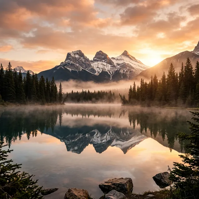
The Great Rann of Kutch in Gujarat is the largest salt desert in the world—approximately 30,000 square kilometres of blindingly white salt flat that, during the dry months (October to March), extends to the horizon in every direction with a featureless uniformity that is simultaneously monotonous and mesmerising. Standing in the centre of the Rann, the landscape achieves a visual purity that is genuinely disorienting: white ground meeting white sky at a horizon line so featureless that your eyes cannot confirm where earth ends and atmosphere begins. The silence is absolute. There are no trees to rustle, no water to flow, no insects to buzz. On a windless day, the acoustic environment approaches the closest approximation of true silence that I have experienced outside of an anechoic chamber.
Photographing the Rann presents a unique technical challenge: how do you create a compelling image of nothing? The answer, I discovered over three visits, lies in the human figure. A single person standing in the Rann—their dark silhouette the only vertical element in 360 degrees of horizontal white—becomes a statement about scale, isolation, and the relationship between human presence and geological indifference. The composition requires discipline: placing the figure small within the frame (typically at one-third height, one-third width, following the classical rule of thirds) maximises the sense of emptiness while establishing the human element as a reference point that allows the viewer's brain to calculate the vastness of the surrounding space. The best light occurs in the twenty minutes before sunrise and after sunset, when the flat white surface picks up the pink, amber, and violet tones of the sky, transforming the monochrome landscape into a pastel watercolour that no filter or post-processing can replicate.
Spiti Valley: Photography at the Edge of Oxygen
The Spiti Valley in Himachal Pradesh exists at altitudes between 3,800 and 4,500 metres—a cold desert landscape of bare, sculptural mountains in shades of ochre, rust, grey, and occasional startling green where glacial meltwater feeds narrow strips of irrigated cultivation along the Spiti River. The silence here is not the flat, featureless silence of the Rann but a textured, geological silence: the sound of wind funnelling through deep river valleys, the distant cracking of ancient rocks expanding and contracting with temperature changes, the occasional rumble of a small landslide on an unstable slope. At 4,000 metres, the air contains roughly 60% of the oxygen available at sea level. Physical exertion—carrying a camera bag up a steep trail to reach a viewpoint above the Key Monastery, for instance—produces a breathlessness that is humbling and mildly frightening for a flatlander.
The photographic reward of Spiti is geological drama. The mountains here are not covered in vegetation that softens their contours—they are bare, eroded, and sculptural, displaying the layered sedimentary strata of ancient seabeds tilted, folded, and fractured by tectonic forces with a clarity that transforms every ridgeline into a cross-section of geological time. The Langza fossil beds—where you can pick up 450-million-year-old marine fossils from what is now a 4,400-metre mountaintop—provide a visceral, physical connection to deep time that makes the human timescale feel appropriately insignificant.
The Key Monastery—a thousand-year-old Tibetan Buddhist gompa perched on a conical hilltop above the confluence of the Spiti and Pin rivers—is the valley's most iconic photographic subject and one of the most spectacularly situated religious buildings on earth. Photographing it at dawn, when the first light hits the white monastery walls while the valley floor remains in blue shadow, produces an image that embodies the Spiti experience: human spiritual aspiration expressed through architecture, set against a landscape of such intimidating scale and indifference that the building's persistence over a millennium feels like an act of defiance against geology itself.
The Andaman Sea: Underwater Silence
Below the surface of the Andaman Sea, off the coast of Havelock Island (now officially Swaraj Dweep), silence acquires a density that is qualitatively different from terrestrial silence. Water transmits sound more efficiently than air—whale songs travel thousands of kilometres through ocean water—but the sounds that constitute human-audible noise (conversation, traffic, construction, media) are eliminated instantly upon submersion. What remains is the sound of your own breathing through a scuba regulator: a rhythmic, mechanical inhalation-exhalation that becomes the auditory centre of your existence in a way that normal breathing never is. Underwater photography in this environment forces a confrontation with a sensory reality that is fundamentally alien to terrestrial experience.
The coral reefs around Elephant Beach and Radhanagar Beach harbour a visual density of colour, pattern, and movement that is overwhelming to photograph precisely because there is too much to compose. The first instinct—pointing the camera at everything, firing hundreds of frames—produces uniformly mediocre results. The discipline that underwater photography teaches is identical to the discipline that landscape photography teaches on land: patience, selection, and the willingness to let most of what you see pass unphotographed while waiting for the moment when subject, light, composition, and behaviour align into a frame worth keeping. A single clownfish hovering in the tentacles of its anemone host, lit by a narrow shaft of sunlight penetrating the water column, with the blue void of open water as background, is a more powerful image than a wide-angle survey of an entire reef system.
The Ethics of Photographing Undisturbed Places
There is an uncomfortable paradox at the heart of this kind of photography: sharing images of untouched places contributes to making them less untouched. Every stunning photograph of a remote landscape, posted on social media with a location tag, functions as an advertisement that draws visitors—some thoughtful and respectful, others careless and destructive. The geotagging dilemma is real: precise location information attached to a viral photograph of a pristine lake or a secluded beach can transform a visit rate from dozens per year to thousands per month, with predictable consequences for the environment, the local community's resources, and the very quality of solitude that made the place photogenic in the first place.
My personal practice has evolved toward deliberate vagueness: I describe regions rather than specific coordinates, I omit trail names and access roads, and I never geotag posts with precise locations. This approach is imperfect—it withholds information from responsible travellers along with irresponsible ones—but the alternative (precise disclosure) has demonstrably catastrophic consequences for fragile environments.
Frequently Asked Questions (FAQs)
What camera equipment do you need for landscape photography in remote locations?
The honest answer is: less than you think. A camera body with good dynamic range (the ability to capture detail in both very bright and very dark areas of a scene), a wide-angle lens (16-35mm equivalent), and a sturdy tripod constitute 90% of the equipment needed for landscape photography. A polarizing filter (to manage reflections and deepen sky tones) and a set of neutral density graduated filters (to balance bright skies with darker foregrounds) complete the essential kit. Weight matters enormously when hiking to remote locations—every additional lens and accessory competes with water, food, and safety equipment for space in your pack. I carry one body, two lenses (a 16-35mm wide-angle and a 70-200mm telephoto), a carbon fibre tripod, and filters. The total weight is approximately 4 kg, which is manageable on multi-hour hikes.
How do you find truly remote, undisturbed landscapes in India?
The most reliably undisturbed landscapes in India are found in high-altitude regions (Ladakh, Spiti, Zanskar, eastern Arunachal Pradesh) where accessibility is limited by terrain and seasonal road closures, in the Andaman and Nicobar Islands (where many islands are restricted or uninhabited), and in the less-touristed sections of major deserts (the Great Rann of Kutch beyond the Tent City tourist zone, the Thar Desert south of Jaisalmer). The key principle is to go where roads end and walking begins—the effort of hiking eliminates 95% of potential visitors and reliably delivers landscapes that car-accessible viewpoints cannot match.
Is it safe to travel alone to remote locations for photography?
Remote location photography involves genuine physical risks—altitude sickness, dehydration, navigation errors, weather changes, wildlife encounters—that must be respected and planned for. The non-negotiable safety principles are: tell someone your detailed itinerary and expected return time; carry sufficient water, food, and emergency shelter for twice the expected duration; carry a first-aid kit with altitude sickness medication if above 3,000 metres; check weather forecasts obsessively; and know your physical limits honestly rather than optimistically. In India specifically, the risks vary by region: high-altitude Himalayan areas require acclimatisation planning and altitude-aware decision-making; coastal and forest areas require awareness of tides, currents, and wildlife. Travelling with at least one companion is strongly recommended for any genuinely remote location photography.

Comments (0)
Be the first to share your thoughts on this article.